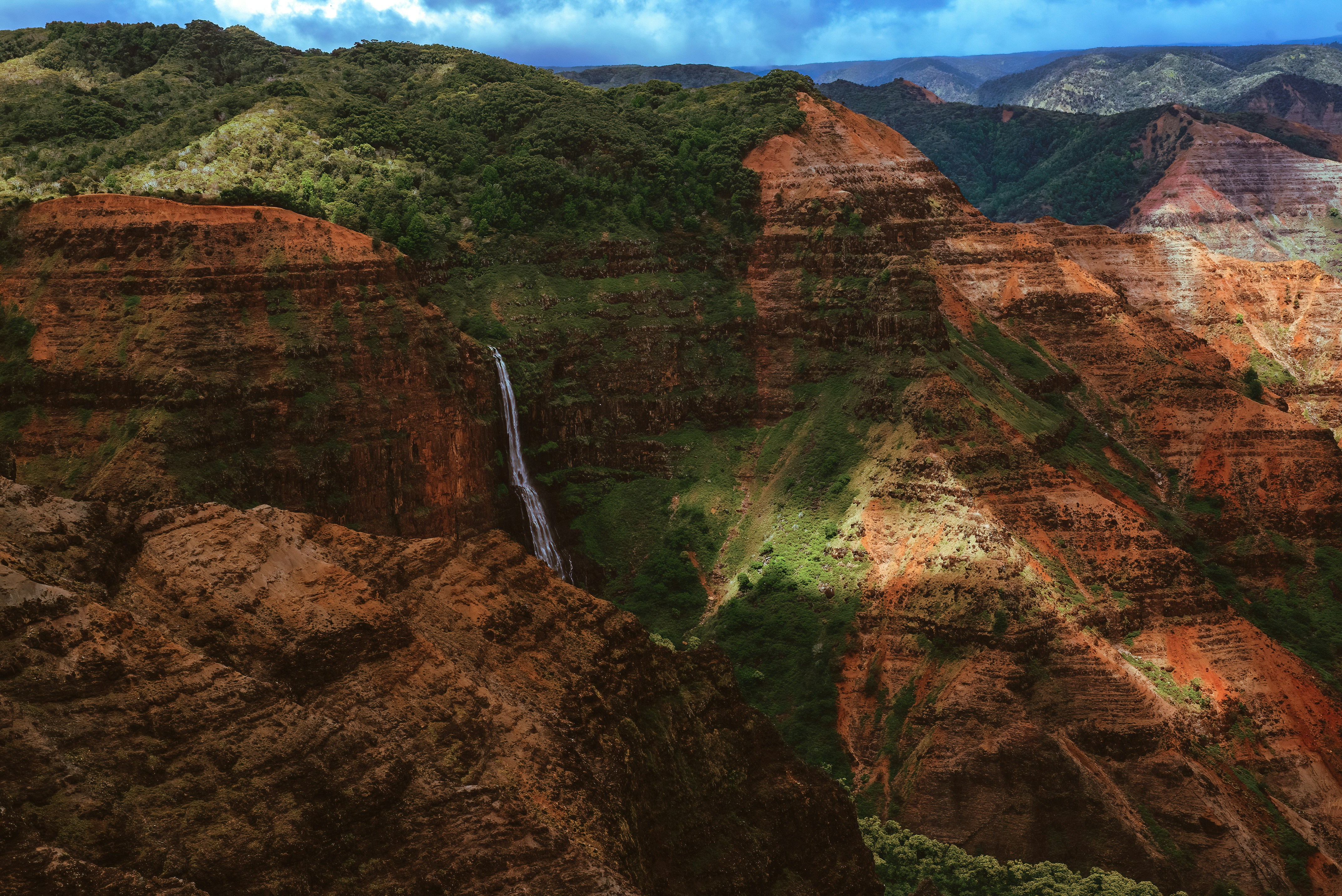
Waimea Canyon is 14 miles long, a mile wide, and 3,600 feet deep. Mark Twain almost certainly never called it the 'Grand Canyon of the Pacific' (the quote is attributed but undocumented), but the comparison sticks because it works. Red walls, green pockets, waterfalls visible from the road. It's the most reliable big-view experience on Kauai.
The canyon is accessible from the road with no hiking required — you drive to the lookouts, get out, look, get back in. But if you spend a full day here rather than a quick morning loop, it becomes one of the best experiences on the island. The day-hiking options above the canyon are genuinely excellent and nearly empty compared to the coastal trails.
Administered by Hawaii Division of State Parks — no entry fee, no permit needed for most activities. Camping permits for Kokee available through camping.ehawaii.gov.
The drive up
From the south shore (Poipu): about 45 minutes. From the north shore (Hanalei): 2 hours. Take Highway 50 west to Waimea town, then turn right on Waimea Canyon Drive (Hwy 550). The road climbs from sea level to 4,000 ft in about 19 miles.
Gas up in Waimea town before you start the climb. There's no gas after that point, and the reserve on an empty tank is not comfortable on a 40-mile round trip through remote terrain.
The drive itself is scenic from the start — views over Waimea town and the coastline open up quickly as you gain elevation. Stop at the first few roadside viewpoints even before the official lookouts; some of the best spontaneous views are in the first 5 miles.
Kokee Road (Hwy 552) provides an alternate entry from Kekaha town — it rejoins Hwy 550 partway up and avoids the initial Waimea town section. Some GPS apps route through Kekaha; either works.
Driving time from the valley floor to the upper lookouts is about 45 minutes without stops. With stops at all the lookouts and the lodge, budget 3–4 hours minimum for the round trip drive-only experience. A full day with hiking takes 6–8 hours.
Lookouts in order
Waimea Canyon Lookout (mile ~10, elevation ~3,000 ft): the classic shot. Big parking lot, sometimes a food truck or two in the morning hours. The canyon stretches both directions from here. Worth the stop — this is the signature view that most photos show.
Pu'u Hinahina Lookout (mile ~13, elevation ~3,400 ft): a better view, in my opinion — you can see further down the canyon and spot Ni'ihau (the 'forbidden island') on a clear day to the southwest. Trailhead for the Canyon Trail to Waipo'o Falls is here.
Kalalau Lookout (mile ~18, elevation ~4,000 ft): looking down into the Kalalau Valley from 4,000 ft — a completely different perspective than the canyon views below. The valley stretches to the Napali Coast. Often clouded in by 10am, so prioritize this stop if you arrive late.
Pu'u o Kila Lookout (end of road, mile ~19, elevation ~4,170 ft): even higher, even more dramatic when clear, and the trailhead for the Pihea Trail. On a clear day the view down into the Kalalau Valley is one of the most spectacular in the state. On a cloudy day (which is often) you're staring at white.
Weather strategy: clouds form at the upper elevations from mid-morning onward. The lower lookouts (Waimea Canyon, Pu'u Hinahina) stay clear longer because they're at lower elevation. If you're arriving after 10am, start with the upper lookouts immediately rather than working your way up — you may find them clear on arrival but clouded by the time you've worked through the lower stops.
Hikes worth doing
Canyon Trail to Waipo'o Falls: 3.4 miles RT from Pu'u Hinahina. Descends into the canyon 800 feet, reaches the top of an 800-ft waterfall with views down the canyon wall. Best hike for the average visitor — significant payoff for manageable effort.
Pihea Trail to Pihea Vista: 2.5 miles RT from Pu'u o Kila. Ridge walk with views into the Kalalau Valley. Often muddy, always beautiful. Go first thing in the morning before clouds form.
Pihea to Alaka'i Swamp: 8 miles RT (Pihea Vista + the full Alaka'i Swamp loop via boardwalk). This takes you through one of the wettest places on Earth — the Alaka'i Plateau. Surreal landscape, native birds, boardwalk through bog vegetation. Plan 5–6 hours. Wet feet guaranteed.
Halemanu-Kokee Trail: 2.5 miles RT from the Kokee Lodge area. Flat(ish) trail through native forest. Good birding. Less dramatic than the canyon hikes but quieter and easier.
Overnight options: Kokee has tent camping and rental cabins. A night up here followed by an early-morning clear-sky lookout visit is the best way to see the upper canyon before clouds form.
Kokee State Park
At the top of the road. Kokee Lodge has a small cafe — the chili is better than you'd expect, the coffee is serviceable, the seating is charming. Open for lunch. Also a gift shop and the Kokee Natural History Museum (free, donation welcome, genuinely informative about the island's ecology and history).
Bathrooms here are your last before returning to the coast. The facilities are basic but maintained.
Camping cabins at Kokee are a unique option — rustic wooden cabins at 3,500 feet elevation, surrounded by native forest, cold at night (genuinely, bring layers). Book through the Kokee Lodge directly. They're popular with hikers doing multi-day trail combinations.
Temperature reality: it can be 20–30°F cooler at Kokee than at the beach. If you're arriving in a tank top from Poipu, you'll be cold at the lookouts by late morning. Pack a fleece layer in the car regardless of how hot it is at sea level.
Native forest ecosystem: Kokee sits within one of the few intact native forest reserves in Hawaii. The 'apapane (crimson honeycreeper) is common here. Feral pigs are a serious problem for the ecosystem — you may see hunting signs and pig traps. This is an active conservation area.
Cell service: essentially nonexistent above mile 8 on Hwy 550. Download offline maps (Google Maps works) and let someone know your itinerary before you head up.
Practical tips
Go up early. Clouds form by mid-morning and can swallow the upper lookouts entirely. A 7am arrival at the lower lookouts, working your way up to Pu'u o Kila by 9am, is the ideal strategy.
Bring layers — it can be 25°F cooler at the top than at the coast. A light fleece and a rain layer in the car costs you nothing and saves your afternoon.
Cell service is essentially nonexistent above mile 8. Download offline maps before you leave. This matters more than people expect when looking for specific trailheads.
Pack snacks and a full lunch. The food truck scene at the lookouts is unreliable (often absent or sold out by noon), and Kokee Lodge has limited options and limited hours.
Pairing suggestion: a Waimea Canyon day pairs naturally with the west side — Polihale at sunset, Ishihara Market poke for lunch, Hanapepe on Friday night for the Art Walk. It's a full west-side day that most visitors skip entirely and almost always wish they hadn't.
Winter vs. summer: the canyon is beautiful year-round. Winter can bring dramatic waterfalls from increased rainfall but also more cloud cover at the lookouts. Summer has more reliable clear mornings. October–November is an excellent shoulder window — the canyon is lush from summer moisture, crowds are lower, and the likelihood of a clear morning at the upper lookouts is good.
Was this guide helpful?